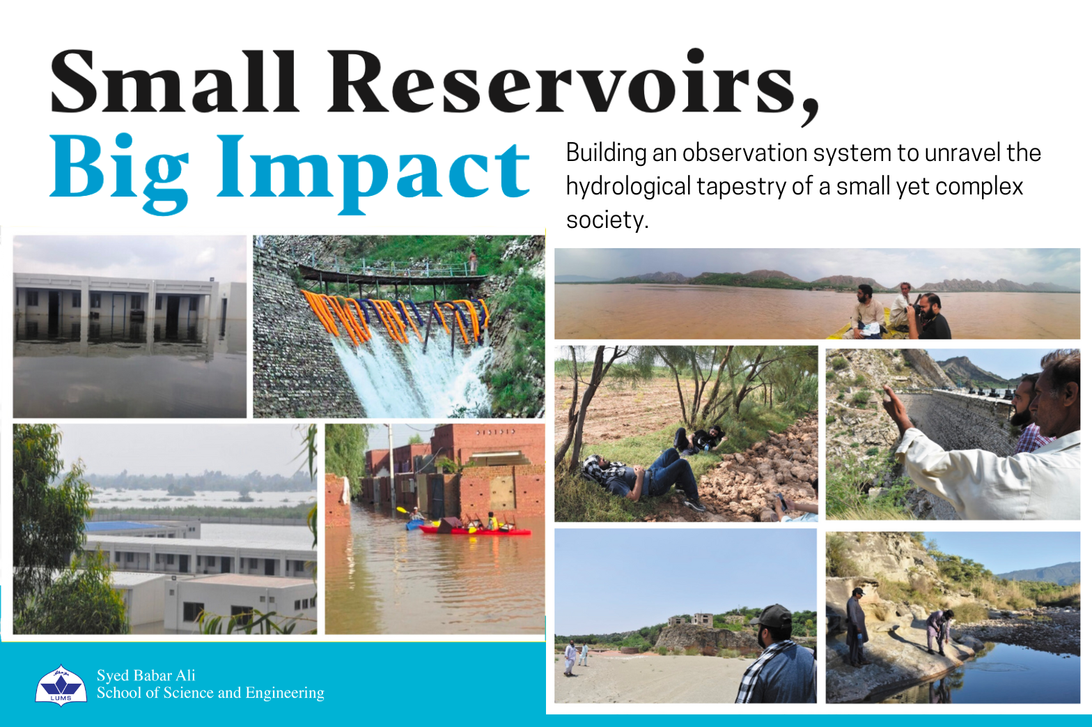
Small Reservoirs, Big Impact: Building an observation system to unravel the hydrological tapestry of a small yet complex society.
Background
In the realm of hydrological studies, small water reservoirs that sustain local communities are often overlooked. The focus remains on large-scale reservoirs and their catchments. This oversight of small water bodies can lead to significantly skewed estimates of critical variables.
Take for instance, the contribution of continental water bodies to the global carbon cycle. It has been reported that the estimated contribution doubles after including the contribution from small lakes and reservoirs. This ties with the observation that globally, small reservoirs are not only more in number but also collectively cover a larger area than large reservoirs.
The undervaluation of the importance of small water systems partially accounts for the lack of attention they receive. Another contributing factor to this oversight is the array of challenges that emerge during the study of these systems. The resulting oversight hinders a comprehensive understanding of the contributions of small reservoirs to socio-economic development and environmental evolution. The case of Pakistan is no different.
So, what exactly is the challenge in studying small water bodies?
The first challenge lies in their number. The Potohar Plateau, which contains over 5% of all the cultivable land in Pakistan is home to over 50 small dams. It is not difficult to see that any on-site data collection system will be infeasible to implement at scale across all reservoirs in the region. At this point, the reader may wonder if the required data could easily be recovered from remote-sensing satellite-based products.
It turns out that the spatial and temporal resolutions of these products are mostly suited to studies of large reservoirs. Innovative techniques are required to downscale the remotely sensed data to this scale where one often has to accept degradation in accuracy. Herein lies the second challenge.
The third challenge is that of complexity. Hydrological processes in small catchments are strongly coupled with community level human factors in a way that does not appear in large catchments. Catchments with very similar hydrology, may evolve entirely differently due to the strong influence of site-specific withdrawal patterns, local governance structures, indigenous knowledge, and value systems. If the reservoir is a controlled one (as in a small dam), the human-water coupling is especially enhanced due to the role of human operators. As with all humans, the judgement of the operators is prone to various biases that arise from an over simplified understanding of the water system. Further, mental models of decision-makers are largely based on experience accumulated over historical conditions that are no longer valid due to climate change. Sadly, such biases are only exposed when a disaster occurs, at which point it is often too late to compensate for it.
Against this backdrop, The Centre for Water Informatics and Technology (WIT) at LUMS has closely been engaged in the hydrological study of small water catchments in Pakistan. One of these is The Namal Lake system situated in the Mianwali district in the Potohar region. Due to the isolated nature of the lake, its small size, and the heavy dependence of the local population on the lake, the Namal catchment is an excellent embodiment of all that is discussed above regarding small freshwater systems.
The Namal Lake System
The Namal lake serves as a reservoir for the Namal dam. Built in 1914, the dam transformed the downstream village of Musakhel and neighboring villages by ensuring higher reliability and profitability of agricultural activities.
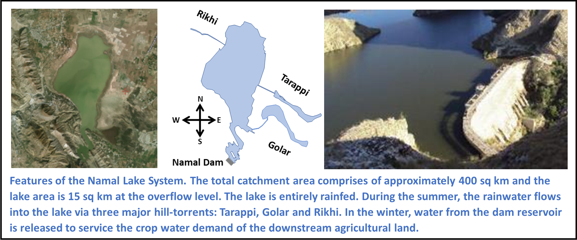
Where the Namal Dam has driven prosperity in the local region, it has also brought forth many causes for local conflict. The objective of flood risk control for the upstream community competes with the objective of irrigation water storage for the downstream community. Influential contractors holding fishing licenses push against opening of the gates to maximize their harvest. A planned forest initiated next to the shores of the lake by the forestry department prevents the reservoir operator to raise the water beyond a certain level. Even for the upstream community, if the level recedes below a certain threshold, the water table of the adjoining area goes too low for tubewells to operate economically. These complex interactions between the local population and the lake ecosystem present many challenges in operating the reservoir gates.
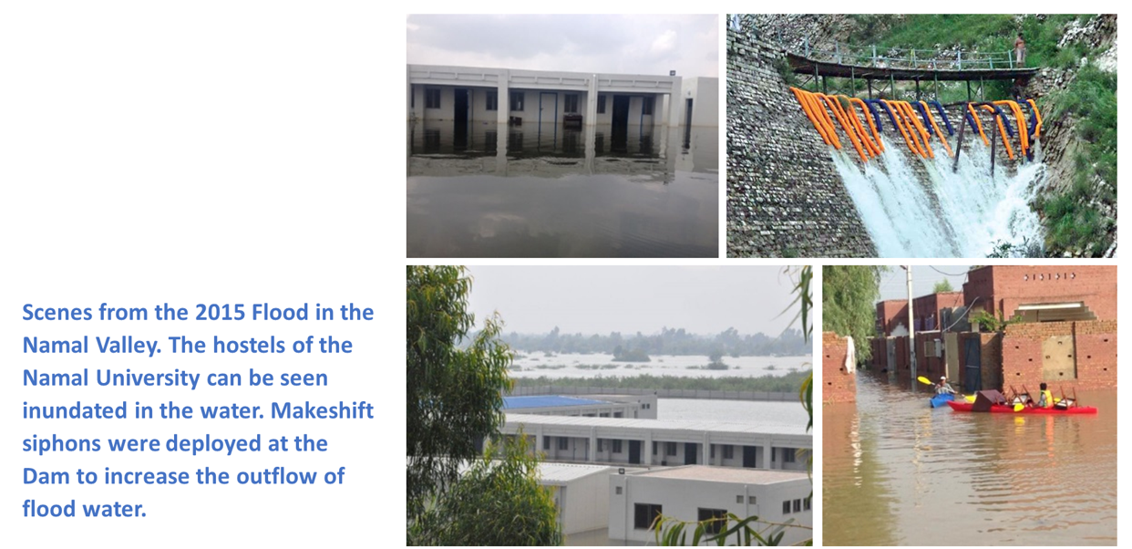
In order to simplify their decisions, the operators resort to heuristics based on past experience. These heuristics often lead to systematic errors in operations, especially with the onset of changing climate patterns. The Namal flood of 2015 is a case in point, where heavy loss to life and property could have been avoided if the reservoir gates were opened early enough to compensate for the unexpectedly high monsoon rains that year.
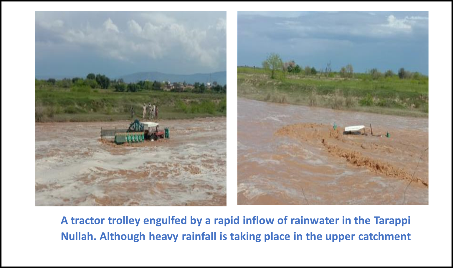
Flooding in the reservoir is not the only threat. Heavy monsoon rains cause huge inflows into the hill torrents that otherwise remain dry all year round. The population of the lower catchment area is frequently unaware of heavy rainfall occurring over the upper catchment area. As a result, many locals are often caught unprepared for the rapid runoff generated in the hill torrents. Vehicles, livestock and even people themselves are engulfed in the fast-flowing water that suddenly appears from upstream. Much of this loss is avoidable by timely detection of rainfall in the upper catchment and broadcasting beforehand to the lower catchment areas.
Project Conception and Deployment of the Sensor Network
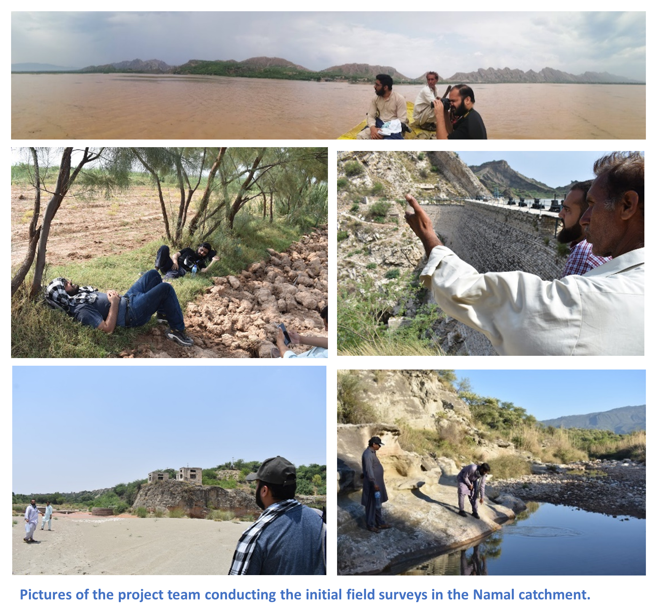
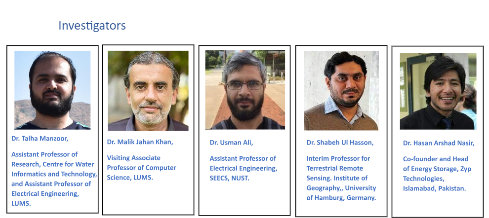
Before joining the Centre for Water Informatics & Technology (WIT) at LUMS in 2019, Dr. Talha Manzoor spent approximately two years with the Faculty of Electrical Engineering at Namal University. During his stay at Namal, he learned about the problems faced by the stakeholders connected with the lake. He realized that the problems could be addressed through early detection of hazards and context-aware management of the dam reservoir. An observation system would need to be deployed to generate the data regarding the local hydrometeorology of the catchment. He initiated a coordination with the Mianwali Canal Division office of the Punjab Irrigation Department for deploying a telemetric sensor network in the Namal Valley. Later on, when he moved to WIT, he obtained an internal grant from LUMS to kickstart the project. The initial field surveys preceding the deployments were done during the covid lockdowns in the grueling June heat of 2020.
By 2021, seven sensor nodes were deployed to measure critical variables such as water level, rain, temperature, and relative humidity. The data collected during the first year showed that measurements in the upper catchment can be used to generate warnings sufficiently early enough to significantly reduce the damage caused by flash flooding in the Monsoon period.
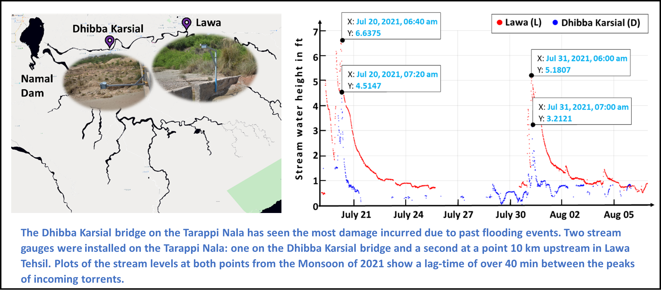
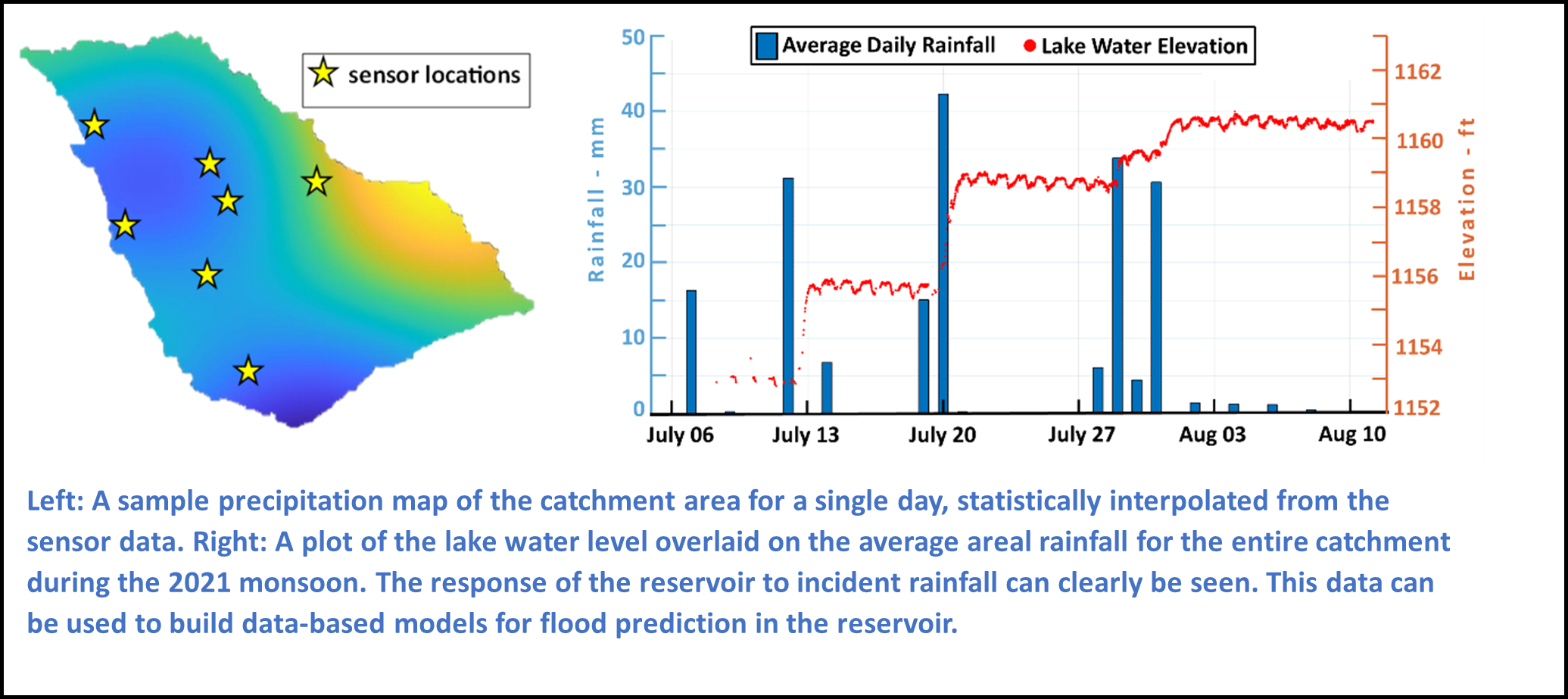
Once the data started coming in, more insights into the hydrological processes of the Namal valley were collected. The project team could now observe how the water level in the lake responded to incident rainfall in the catchment. The data that encodes this response could now be used to build models to predict future responses of the lake to expected storm events.
A collaboration was formed with Dr. Hasan Arshad Nasir, an expert in control and system identification of water systems from SEECS, NUST. He supervised the construction of the hydrological model of the catchment and its simplification to data-based mechanistic models that could eventually be used to generate a control policy for the dam gates. Dr. Hasan would eventually leave academia to embark on his entrepreneurial journey. His work on the project laid a solid foundation for the team to build upon. Dr. Usman Ali, another control theorist from SEECS, subsequently took responsibility for, and is currently leading, the development of the advisory framework for gate.
Installing and Maintaining Sensor Nodes at Remote Locations
Spearheading the deployment activities for the sensor network, is a team of devoted staff members from the Centre for Water Informatics & Technology, comprising RA’s, technicians, and field engineers. Deploying a sensor on a stream takes weeks of planning (not including the time taken to fabricate the sensor itself).
Once the team identifies the need for creating an observation point in a specific area, the resident field engineer at Namal surveys the area. The purpose of the survey is to identify sites where it is physically feasible to install the pole structure for mounting the sensor. Major factors that need to be considered include complexity of the mounting pole required at that location, accessibility for sensor maintenance, and protection from tampering of the sensor.
Since the devices broadcast their data over cellular mobile network, the signal strength of the area also needs to be considered. Once the field engineer identifies feasible locations, they are discussed with the staff at WIT who then further shortlist the locations. A trip is then planned to the valley where each shortlisted site is visited. Measurements are taken, pictures are shot, and where required, aerial drone footage is recorded to capture all information related to the final sites selected for deployment. This visit can take multiple days. The mounting pole is manufactured in Lahore and then transported to Namal. The design of the pole must be suitable for transportation. A modular approach is followed so that separate components are transported and then assembled on site.
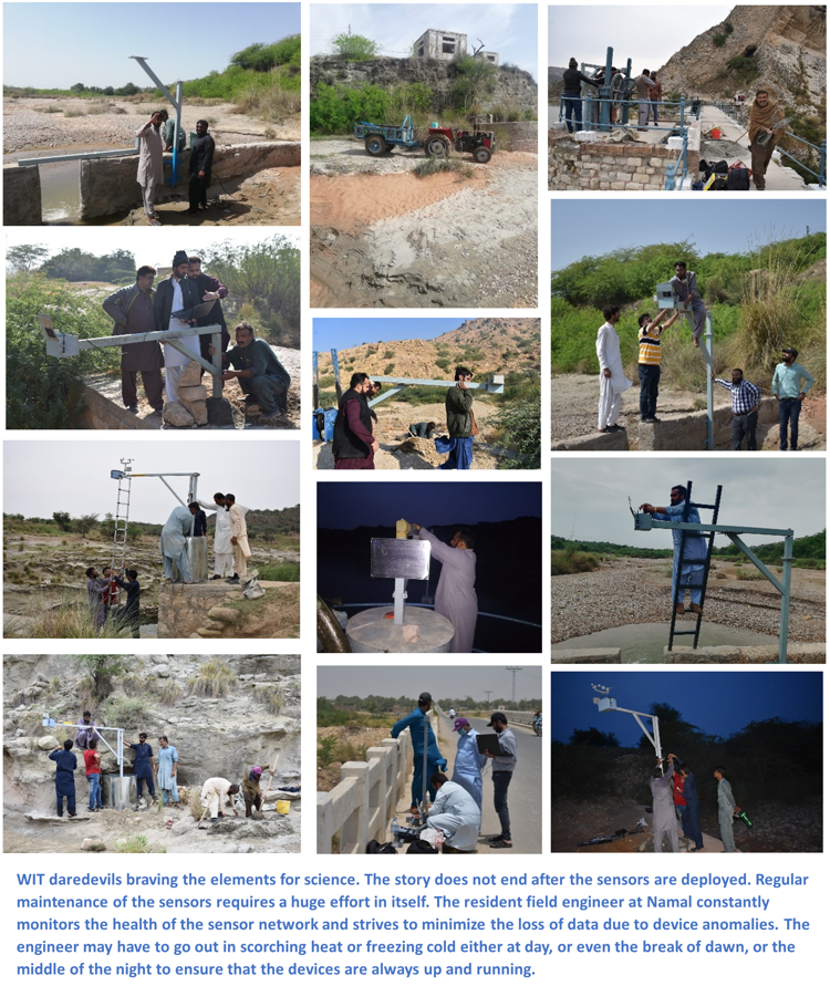
Civil work is required for all stream installations. Sometimes the raw material (gravel, cement, steel rods, etc) can only be transported through tractor, sometimes only by boat, and sometimes only by manual labor over several hundreds of meters. Thankfully, water is available in abundance on site!
Local experts and partners play a critical role in the deployment and maintenance of such a sensor network at remote locations for long durations. Dr. Malik Jahan Khan, recently relocated to the Computer Science department at LUMS, was with the Namal University during the initial phase of the project. Born and raised in the valley, Dr. Malik provided the team with crucial guidance in conducting field surveys, obtaining permissions for installations, connecting with the local population, mobilizing local resources for project activities, and liaising with administrative offices. As an expert in Artificial Intelligence, he is also leading the effort to construct AI-based hydrological models for flood prediction from the gathered data.
International Collaborations and Expansion of Horizons
Starting from 2022, funding for a project titled “Securing Socio-Economic Stability and Data-Driven Resilience for Ungauged Namal Valley Watershed at Monsoon Margins” was obtained for two years from the German Academic Exchange Service (DAAD). Dr. Shabeh Ul Hasson, with the Institute of Geography at the University of Hamburg, Germany is leading investigations from the German side. Over the past two years he has provided valuable support to the project partners in observational analysis, terrestrial remote sensing, and hydrological and meso-scale climate modelling relevant to the project activities.
The project has now generated over 3 years of data at high temporal and spatial resolutions, which is unprecedented for the study area. The project has produced two MS theses, one each at LUMS and NUST. Two papers have been published in peer-reviewed conferences, and multiple publications are in the pipeline. Three workshops have been conducted at NUST, Namal, and LUMS, with another planned by the end of the year. The funding from DAAD is expected to be extended to cover 2024. Additional funding has also been acquired to generate high resolution bathymetry of the lake through sophisticated LiDAR sensors mounted on drones and boats. Several scientific innovations have been produced. But that is a story for another time!
Past and Present Team Members
• Muhammad Sheraz, Field Engineer.
• Hamza Tariq, MS student in Electrical Engineering at NUST.
• Hassam Arshad, MS student in Electrical Engineering at LUMS.
• Muhammad Kashif, MS student in Electrical Engineering at NUST.
• Abdul Waheed, Field Engineer.
• Allah Bakhsh, Electrical Technician.
• Muhammad Suleman, Mechanical Technician.
Acknowledgements
The project team duly acknowledges the entire WIT staff that supports the ecosystem that has made such efforts in the field possible, not just for the Namal project, but many other projects currently running at the Centre. Dr. Iqra Abdullah from Akhuwat University led a household survey in Namal, which revealed key insights into the human-water interactions in the valley. We also acknowledge the support provided by Namal University in the initial phase of the project. Maryam Arif and Aliha Bukhari provided valuable help in the initial writing process of this article.

